
![2009 [BADGE].png](https://static.wixstatic.com/media/1a0618_96d254a72f314d68bd1d560123383b05~mv2.png/v1/crop/x_0,y_116,w_1667,h_1436/fill/w_137,h_118,al_c,q_85,usm_0.66_1.00_0.01,enc_avif,quality_auto/2009%20%5BBADGE%5D.png)
Binny Craig – A 3D map view!
- Editor
- Oct 3, 2025
- 3 min read

Binny Craig sits prominently in the rolling landscape near Uphall, making an enticing feature for a short and invigorating walk. At a relatively modest 221 metres (725ft) high, it offers spectacular 360 degree views from the top, and on a clear day it’s like standing atop a 3D map where you can get a fantastic overview of all the landmarks in our local area - and far beyond.

Like a smaller version of Castle Rock in Edinburgh, Binny Craig is a crag and tail formation created by the movement of a glacier in the Ice Age. As the glacier moved east across the landscape here, it came up against a hard dolerite intrusion which withstood erosion. The gentler grassy slope of the tail side makes for a very rewarding short walk to the top.
According to the British Geological Survey, Binny Craig may have been quarried for its hardwearing rock on the east face, but of greater importance was the nearby Binny Quarry. Now infilled and under Binny Golf Course, it was one of the most significant sandstone quarries in Scotland and provided high quality stone for some of Edinburgh’s best-known buildings and monuments including the Scott Monument and the National Galleries.
There are a couple of access routes to Binny Craig, and this time I started from Forkneuk Road in Uphall. Park at Uphall Community Centre if it’s not too busy, or on Forkneuk Road, and walk east along Forkneuk Road. Follow the road around as it turns to the right then left, then you will see a farm track heading towards Binny Craig which is visible straight ahead.
I picked a bright, crisp sunny autumn day to head up the crag. Moving through open farmland, fields were being ploughed, the hedges bejewelled with bright red berries and alive with birds. Once across the first field, the route is well-signposted and takes you over a bridge over Binny Burn and alongside farmed fields on mostly grassy tracks. The ground starts to gently rise as you head up a slightly harder surfaced path towards a house, then at the corner take the track straight ahead, and cross the tarmacked Binny Craig Access Way. It’s clearly signed here too, and the path goes between two fields with livestock fencing.
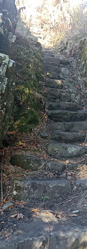
There are then some picturesque but rather rough stone steps to navigate, before you’re onto the grassy slope that leads to the top of the crag. There are just faint paths in the grass, and it gets steep abruptly so is only for the sure-footed.


Your short climb to the top is rewarded with spectacular 360 degree panoramic views.
On a clear day you can pick out all the features of the landscape - the three bridges striding across the Forth, the Ochils, Berwick Law and Bass Rock in the distance to the east, the pink shale bings slumbering in the fields closer home, the plain of Almond Valley with all its settlements, and Edinburgh beyond. Take a pair of binoculars and see how much you can pick out.
Take care near the east edges, there are sheer falls on the rocky side, and it’s not advisable to head up here when it’s wet as the grass surface is very slippery.
Before heading back, take the time to meander around the crag at a lower level, where there is a network of faint paths. With the sheer rough rock face looming beside you, it’s like being in an exotic landscape and there are plenty of good spots for a flask and picnic.
Return the way you came, and if you have time and energy for a short add-on and different terrain, meander through Uphall Community Woodland before heading back to the car. You can be sure of a good scone at Williamson’s Garden Centre cafe at 17 Houston Mains Holdings, Uphall, EH52 6PA
Approx 5.2km from Uphall Community Centre to Binny Craig summit and back
Published in Konect October 2025
Author: Helen-Jane Gisbourne


Comments